Abu Dhabi Maps and Orientation
(Abu Dhabi, United Arab Emirates, UAE)
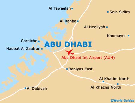
The bustling capital of the United Arab Emirates, Abu Dhabi is both a city and an emirate of the same name. Located on the north easterly shore of the UAE, Abu Dhabi stands on an island shaped rather like a 'T' and is surrounded by the Persian Gulf.
Abu Dhabi is connected to the mainland of the United Arab Emirates by both the Mussafah Bridge and the Al Maqtaa Bridge, which are linked by the Al Khaleej Al Arabi Street and the Sheikh Rasheed Bin Saeed Al Maktoum Street respectively. The very heart of the city is shaped rather like a wedge and edged by the coastal road known as the Corniche.
Maps and Orientation of the City
The streets of central Abu Dhabi are organised in a logical fashion and maps are easy to understand. However, do bear in mind that traditional road names by differ with those listed on maps, which can lead to some confusion at times, with Airport Road often being referred to as Maktoum Street.
Abu Dhabi is divided into a series of districts, such as the Al Khalidia, Al Layyeh, Al Qasimia, Al Qharb, Al Sharq and Port Khaled. Recently the city has also been organised into various zones, with each of the roads being numbered accordingly. The roads with odd numbers stretch across the island, while those with even numbers run in the opposite direction.
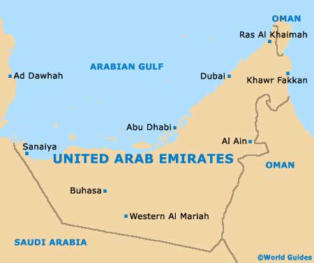
- Abu Al Abyad - south-west
- Al Ain - east
- Al Mirfa - south-west
- Al Samha - north-east
- Bani Yas - east
- Bu Hasa - south-west
- Dubai - north-east
- Habshan - south-west
- Jumeirah - north-east
- Kish Island (Iran) - north-west
- Mina Jebel Ali - north-east
- Musaffah - south-east
- Sharjah - north-east
- Sweihan - east
- Tarif - south-west
Map of the United Arab Emirates
Map of Abu Dhabi